
Shifting Sands: Maryland Keeps an Eye in the Sky on Vulnerable Areas
Drone mapping observes dune changes at Assateague Island
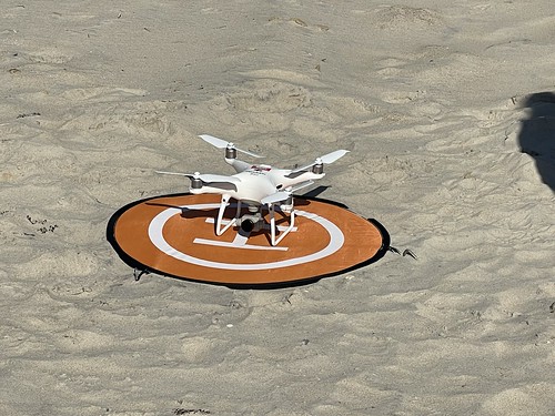
A Maryland Department of Natural Resources drone prepares to launch to survey Assateague Island’s sand movement. Maryland DNR photo
The impact of rising seas, stronger storms, and an eroding shoreline might leave the future of Assateague Island up in the air – and that’s exactly where the Department of Natural Resources is monitoring the coastal property with the use of aerial drones.
Unique among Maryland’s public lands, Assateague State Park comprises part of a barrier island that provides a peaceful beach respite to more than a million visitors a year. But the relaxed atmosphere belies the island’s tumultuous place protecting the mainland from the powerful forces of the Atlantic Ocean.
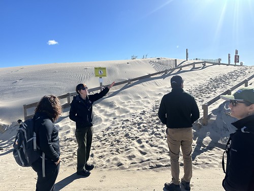
Assateague State Park Manager Angela Baldwin shows the high dune wall that keeps ocean water from reaching the park’s campground. Maryland DNR Photo
Visitors to Assateague often recognize a distinguishing feature – a high dune wall that separates the beach from the campground and other parts of the park. This is a manmade structure, part of an artificial dune complex constructed in the 1970s to supplement the existing natural barrier dunes and continually being expanded; by the 1990s the high wall was in place to protect the park’s infrastructure – about 350 campsites that are often fully occupied from spring into fall, one main road, and a bridge back to the mainland. Ranger Angela Baldwin, manager of Assateague State Park, stresses that this wall is “needed to protect life and property from the awesome power of the Atlantic Ocean.”
A couple major storms including Superstorm Sandy in October 2012 and Winter Storm Jonas in January 2016 did break through the dunes, washing out the wall and causing a lot of damage inland.
“That’s always a possibility in our minds, because any big hurricane or nor’easter that makes a direct hit on the island has the potential to knock out this dune,” says Baldwin. “Assateague is an economic driver and one of the gems of the Maryland State Park system and the entire state.”
Generations of visitors have come to Assateague Island. But likely no two generations have experienced the island in the exact same way. Due to these forces and other factors, Assateague is constantly changing shape.
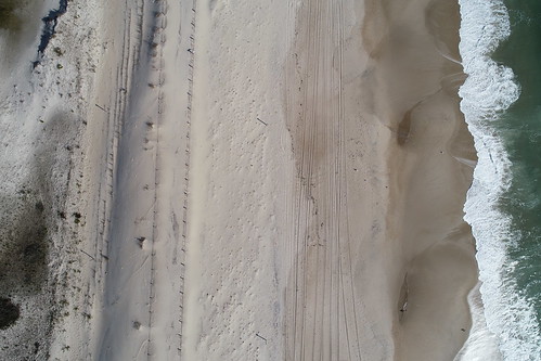
An aerial drone image shows Assateague’s shoreline from above, including the high dune wall and part of the campground with vegetation. Maryland DNR photo
“The beach used to be much bigger,” Baldwin says. In years past the ocean’s wave energy would dissipate by the time it reached the dunes and beyond, but now the island as a whole is losing sand. In fact the sands accumulating on the manmade dune are actually taking sand away from the campground area, which now has more vegetation than in the past. While barrier island movement is natural, the dunes at Assateague are important to protect the infrastructure and communities behind it. Despite the use of sand dredged from Ocean City to help supplement sand loss on Assateague’s beach, the island is sand-starved.
The department’s Chesapeake and Coastal Service has been working with the Maryland Park Service since 2019 to monitor these changes and assess vulnerable properties. Working with Salisbury University, the department has been creating maps of where Maryland is vulnerable to climate change and where there are rare, threatened and endangered species that could be at risk.
“Assateague Island came up as highly vulnerable to climate change due to sea level rise,” says Kate Vogel, coastal resilience planner for DNR. “Dune vegetation, crab species, nesting birds and other species would be affected.”
To monitor this movement of sand, DNR uses aerial drones to take thousands of images that will create a 3D “map” – a process known as photogrammetry.
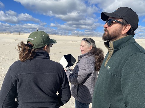
DNR restoration scientist Alison Santoro, center, controls a drone as it flies over Assateague State Park, as DNR Secretary Josh Kurtz observes the aircraft in flight.
Drone footage will make monitoring easier, as the aerial imagery provides an otherwise unseen view, and over time we will be able to see where we are gaining or losing sand,” Vogel says. “We’re trying to establish a baseline and then view changes. In the future we’ll be able to see a complete picture.”
Alison Santoro, restoration scientist, leads the Chesapeake and Coastal Service’s drone monitoring program and pilots the small remote-control aircraft. The use of drones has caused “an explosion in data collection,” Santoro says.
“What we’re doing is called ‘structure from motion,’ making a 3D model from photographs taken from throughout the landscape,” Santoro says. Her work at Assateague follows similar monitoring work being done for a shoreline restoration project on Deal Island in the Chesapeake Bay.
DNR conducted its first flight over Assateague in October. On a brisk fall morning, Santoro and Vogel walked up and down the two-mile beach at Assateague to set GPS data points on the beach to lock the image into place for the drone to capture. Santoro launches the drone to take the photos – 1,500-2,000 photographs of points on the Assateague beach. During the operation, the drone runs the flight program on its own, although Santoro needs to keep it in sight to track the drone’s progress and safe operations.
Later the photos will be exported and run through a computer program to produce a 3-dimensional model, which looks “a little like a video game rendering of the landscape.” The model incorporates GPS points to assign latitude and longitude, fixing it in place on the Earth’s surface.
DNR can compare before and after images using Google Earth and satellite photos from the past. Santoro plans to fly the drones twice yearly to document the sand’s movement; another flight will take place in spring.

DNR’s drone mapping of Deal Island produced this “dense point cloud” of the shoreline; similar images will be produced of Assateague Island. Maryland DNR image
“The 3D model gives us extra depth to measure the amount of sand moving, as well as its movement on the landscape,” Santoro says.
That is helpful to the department in its planning efforts for the park, and also for educating the public.
“It helps people understand how where you live and recreate is changing,” Vogel says.
Baldwin is excited about the opportunity to share this information with Assateague’s loyal visitors.
“We have people who have camped here for many years, some back to when we opened in 1965,” Baldwin says. “We hope to put together a map of how it’s changed and use this information to guide planning for the future.”
Article and photos by Gregg Bortz, Media Relations Manager for the Maryland Department of Natural Resources.