
One Year In, DNR Scientists Monitor a More Natural Way to Protect a Shoreline
Living shoreline project at Franklin Point State Park aims to control erosion and promote marsh habitat
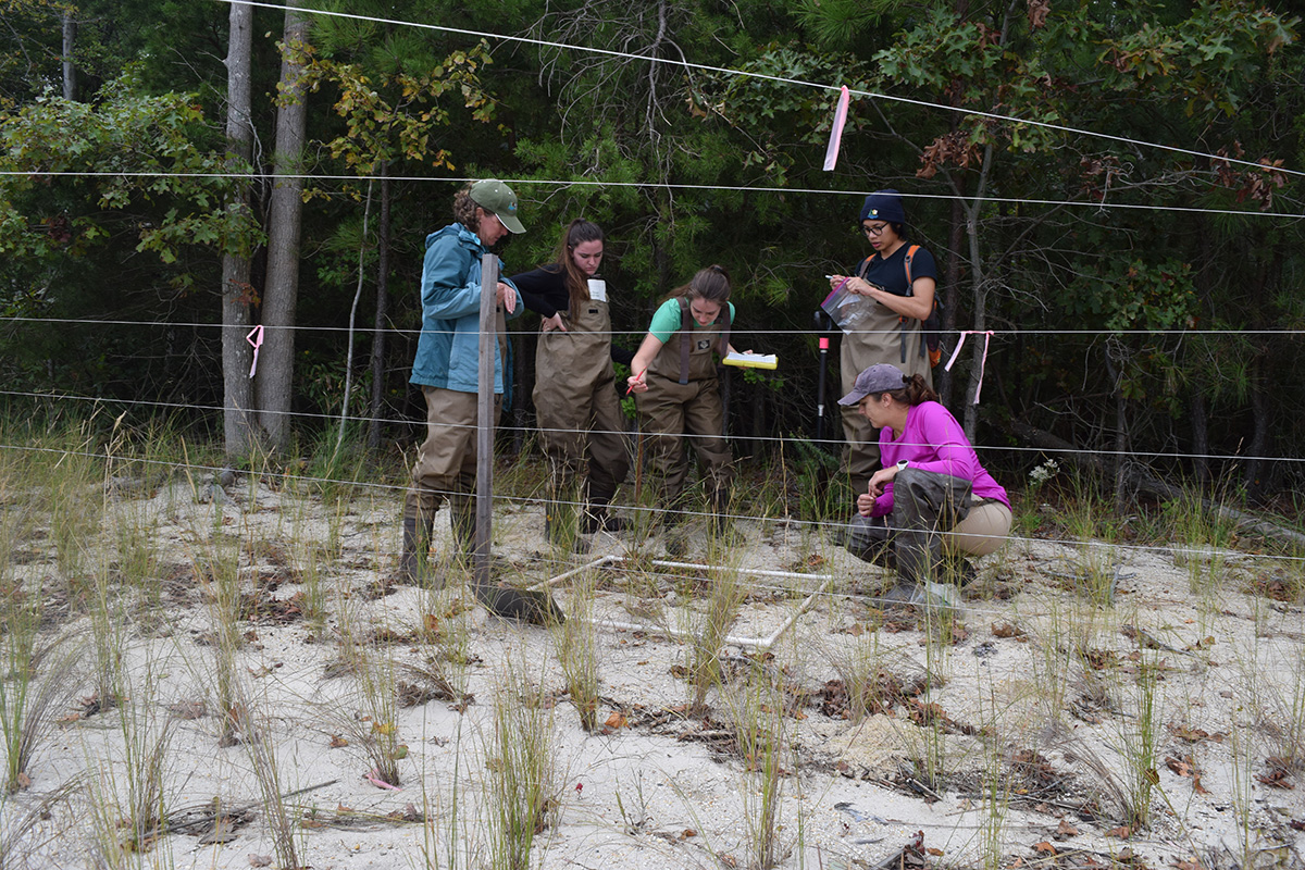
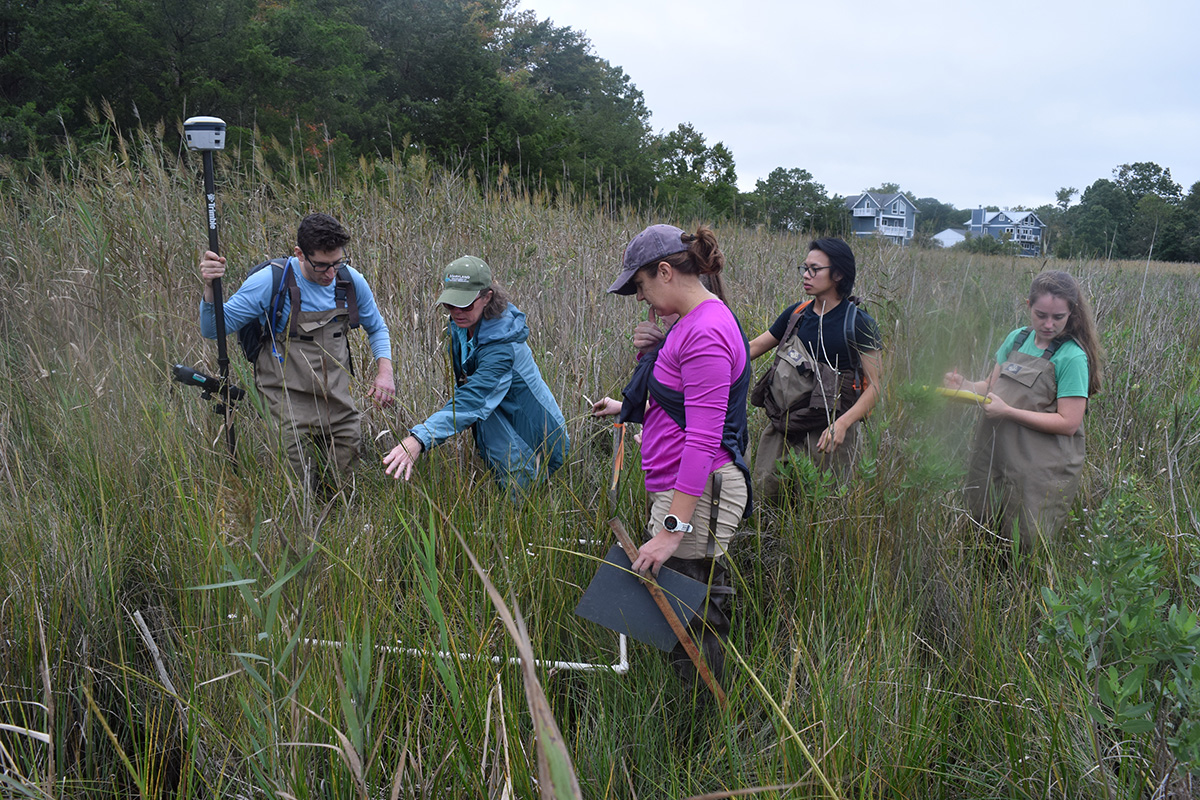
Maryland Department of Natural Resources staff count off saltmarsh hay stalks in a quadrat at the Franklin Point State Park living shoreline. Photo by Joe Zimmermann.
The plot seemed to have vanished. Though the GPS indicated the site was within feet, there was no sign of it, and the team worried they had mistaken it for another area already collected, one long march through the tall reeds ago.
Then, Sarah Hilderbrand, a senior restoration specialist with the Maryland Department of Natural Resources, yelled out, “I see it!”—and there it was, a thin white PVC pipe nestled in the mess of reeds, barely noticeable.
The team, made up of DNR Chesapeake and Coastal Service staff, got to work. They laid down a white quadrat frame and started counting off the species of plants they saw there, the density of vegetation, the height of stalks, the sediment type and the elevation.
They were part of a project to actively monitor the living shoreline built at Franklin Point State Park, which sits along the Chesapeake Bay in Anne Arundel County. This is one of the first projects of its kind to collect before-and-after data on how the anti-erosion efforts are protecting the landscape while providing a healthy marsh habitat. It was built through a partnership with Arundel Rivers Federation, an Anne Arundel County environmental organization.
“We have this unique chance to get the before, so we can document what was happening without any work there, and then the after, of what has changed and what has worked,” said Becky Swerida, who manages the project as a DNR stewardship coordinator for the Maryland Chesapeake Bay National Estuarine Research Reserve.
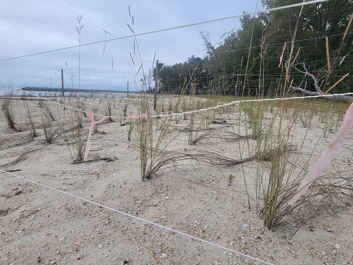
When visitors arrive at Franklin Point State Park, they see a beach dotted with wooden stakes connected by thin white ropes that mark off stretches where dozens of small grasses grow, evenly spaced apart. This is the shoreline project’s crop of Spartina patens, or saltmarsh hay, the root systems of which will strengthen the structural integrity of the establishing high marsh.
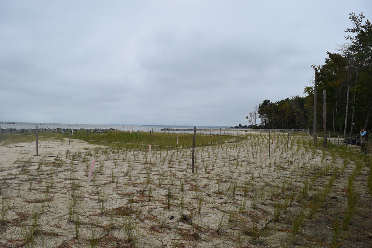
A crop of saltmarsh hay fills the shoreline at Franklin Point State Park. Photo by Joe Zimmermann.
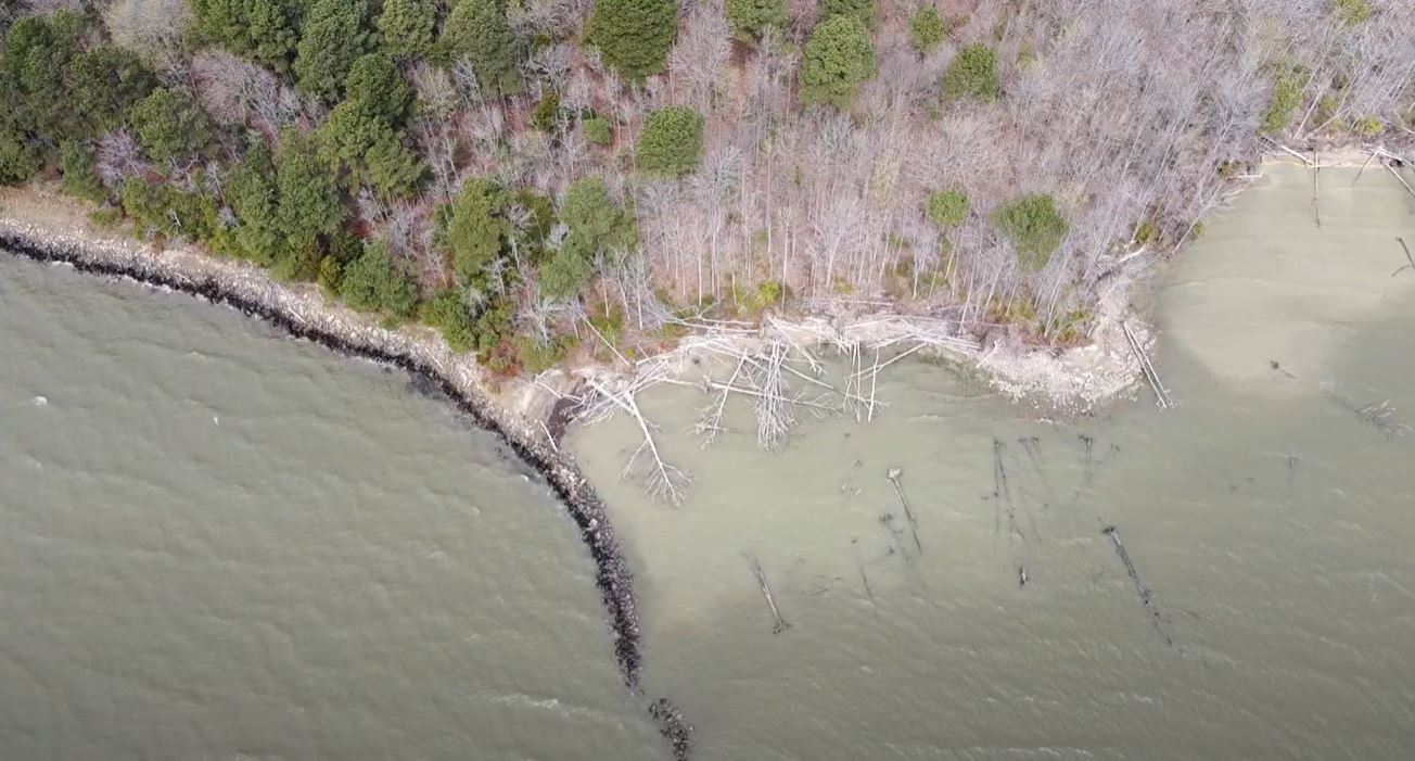
The beach before the living shoreline was built, showing heavy erosion. Photo by Phillip Stafford, Maryland DNR.
“That had been actively eroding land before,” said Ari Engelberg, a DNR implementation and accountability manager, overlooking the beach. “These plants that we’re putting in are really important to locking it in and creating a stable beach system.”
“We try to do it the greenest way we can and let the plants do the work,” Hilderbrand said.
While traditional armored shorelines typically rely on bulkheads or rock abutments to protect the coastline, living shorelines use natural elements to stabilize the shore while also promoting a healthy ecosystem.
Studies have shown the approach is effective at reducing erosion, and can be more effective than traditional hardened shorelines that require more maintenance. Research has also documented living shorelines benefits for producing habitat areas and soil types closer to natural shorelines.
The Franklin Point project uses rock abutments that are placed off the shore that work in conjunction with the marsh plants, but the stone barriers also include gaps to allow fish and other animals to still access the shore and the marsh beyond it.
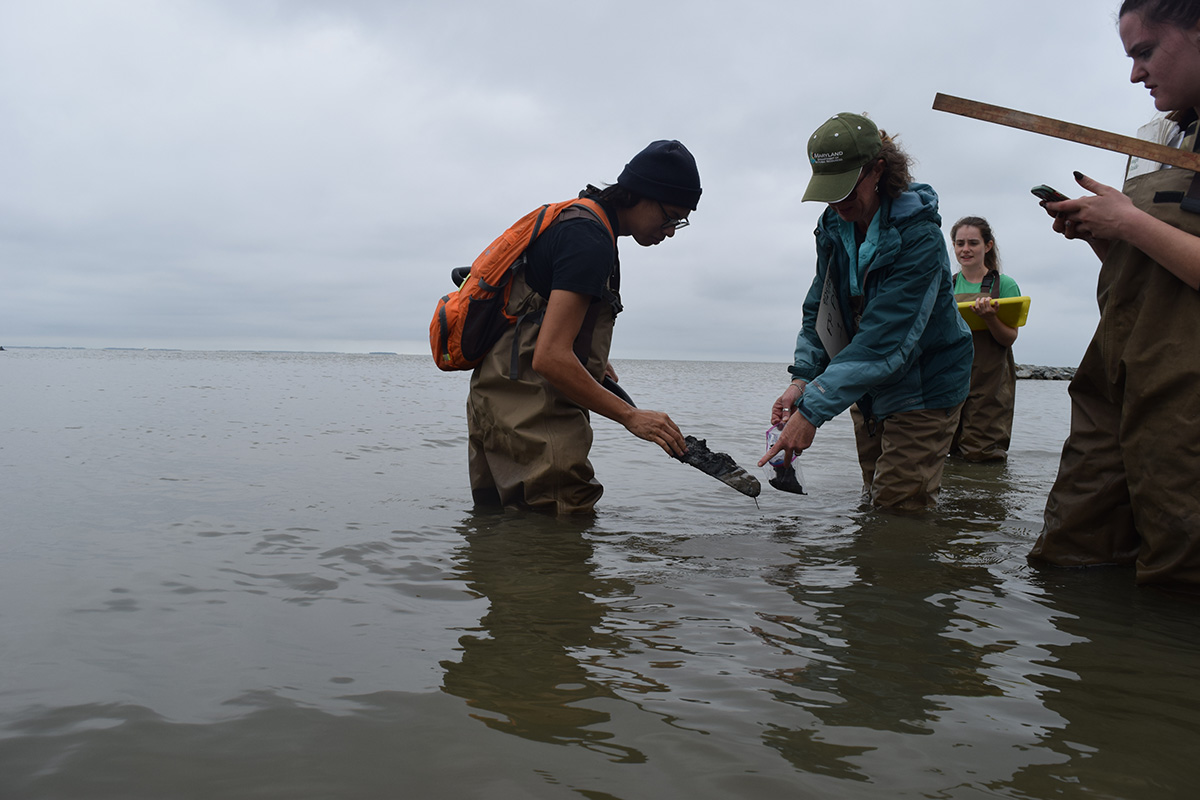
DNR staff collect sand for sediment analysis. Photo by Joe Zimmermann.
For the Franklin Point State Park shoreline, DNR partnered with Arundel Rivers Federation, an environmental organization focused on protecting and restoring the waterways of Anne Arundel County. Arundel Rivers Federation managed the project and facilitated community outreach.
“If there’s a buzzword in environmental restoration work these days, it’s resilience. And this project is resilience in action,” Executive Director of Arundel Rivers Matt Johnston said. “Here’s a public park that was losing feet of land and habitat to every coastal storm. Rather than building some seawall that might have held back the waves for a few years and offered no environmental benefits, DNR, Arundel Rivers, and our partners created a marsh ecosystem that will protect the park and adapt over time as sea levels rise.”
He said the partners also built a public access path so residents could enjoy the Bay at the park and “experience resilience in action.”
Arundel Rivers received $70,000 for the design and $1.46 million for the construction of the project. The organization contracted Coastline Design for design and Resource Restoration Group to build out the site. The project brought 18,250 tons of sand and 5,130 tons of rocks to the site, as well as 35,700 plugs of marsh vegetation and 127 trees and shrubs.
Swerida said they have seen evidence of habitat use at the project site, from horseshoe crabs to terrapins and birds, which is a promising sign of how the restored land could benefit wildlife.
The site shows a careful balance of management and allowing nature to function, even down to the thin ropes that crisscross the spartina plantings, which keep the geese away while the plants establish their roots.
“The resident geese are often lazy. Even with a small barrier they’re likely to just go elsewhere,” Hilderbrand said. “At the beginning there are just plugs of grass, and they’d pull them out like popsicle sticks if not protected.”
The monitoring project started in 2019 and will continue for at least three years after the construction, Swerida said. Her team collects data on plants and the landscape in order to get a full picture of the effects of the project. This will inform restoration science and give future projects a sense of what methods work, Swerida said.
The DNR team spent a 9-to-5 day collecting data at five transects, slices of land with five plots set at different distances from the shore. Though it started with the discovery of four-leaf clovers, the day was marked with setbacks, from lost plots and thick reeds to a battery-depleted GPS and boots stuck in the mud. Still, spirits stayed high as the team completed the work.
The Maryland Department of Environment tidal wetland compensation funds brought $200,000 to the project, while the rest came from the Resiliency through Restoration Initiative, which DNR’s Chesapeake and Coastal Service started in 2017. These funds are dedicated to projects that increase both environmental and community resiliency.
DNR’s Grants Gateway allows governments and other organizations to apply for technical and financial support for “projects that foster healthy ecosystems, communities, and economies that are resilient in the face of change,” including shoreline projects.
DNR staff analyze a transect in a more heavily vegetated area of marsh. Photo by Joe Zimmermann.
Saltmarsh hay build up root systems that help strengthen the shore. Photo by Joe Zimmermann.
Swerida said that community element is critical to the Franklin Point project. In addition to protecting the natural environment of the park, the project safeguards the road and houses in the area. If the peninsula that the park sits on eroded away, it would expose the larger community behind it to further erosion, she said.
She is also working to involve residents in the restoration work, including a plan to set up photo stations where people can submit photos of changes to the shoreline through MyCoast.
Swerida said DNR will eventually share the data and analysis on the living shoreline in an interactive story map that interprets the information for the community.
“Living shorelines and natural based features have huge benefits not only environmentally but for communities, for people as well,” Swerida said. “Monitoring is important, monitoring is overlooked all the time, and monitoring in a more data-rich way that doesn’t have to be a huge lift, doesn’t have to be really expensive. It can be interesting and involve the community.”
More information about living shorelines and how to install one on any property can be found on the Maryland DNR website.
By Joe Zimmermann, science writer with the Maryland Department of Natural Resources.