MDEM Newsroom MDEM Newsroom
Maryland 9-1-1 Board Recognizes Susan Greentree with the 2026 Steve Souder Lifetime Achievement Award
March 27th, 2026HANOVER, MD (March 26, 2026) — The Maryland 9-1-1 Board today recognized long-time public safety stalwart, Susan Greentree, with the Steve Souder Lifetime Achievement Award. The award is presented annually to an individual who has “displayed significant dedication and leadership in advancing the 911 system” in the State of Maryland, as well as to those who have assisted with the deployment of Next Generation 9-1-1 (NG9-1-1) systems.
“The Steve Souder Award is named after a true pioneer in our field, and it requires a recipient who leads with both vision and grit,” said Russ Strickland, Maryland Secretary of Emergency Management. “This award not only recognizes Sue’s long career as a 9-1-1 specialist and supervisor on the front lines, but also her extraordinary dedication to enhancing the entire State’s 9-1-1 system through policy and advocacy work at the State and national level. Sue’s commitment to improving 9-1-1 ensures our systems will save lives for decades to come.”
Mrs. Greentree has been involved with the 9-1-1 system for more than 35 years. During her tenure as a police communications administrator and fire communications official on the front lines of emergency calls in Anne Arundel County, she spearheaded significant advancements and improvements in the field.
In addition to her service at the local level, Mrs. Greentree also dedicated much of her time to shaping state 9-1-1 policies. She represented the Association of Public-Safety Communications Officials on the Maryland 9-1-1 Board for more than 20 years, providing critical 9-1-1 Trust Fund stewardship and a voice for 9-1-1 specialists at the State level. Mrs. Greentree was also appointed as a member of The Commission to Advance Next Generation 9-1-1 as a representative of the Maryland 9-1-1 Board, and she routinely provided testimony and letters of support for legislation that advances the career and the community to which she has devoted her life. She is also a past president of the Maryland Chapter of the National Emergency Numbers Association, a nonprofit organization dedicated to the advancement of 9-1-1 operations, technology, education, and policy issues.
Maryland State Senator Cheryl C. Kagan noted, “How fitting that the fabulous Sue Greentree, whom I’ve had the pleasure of working with in 9-1-1 leadership and who has spent more than 35 years serving 9-1-1, was honored with the Souder Lifetime Achievement Award (the first presented to someone not named Steve Souder!) in recognition of her dedication to and impact on our emergency response system.”
The Maryland 9-1-1 Board was the first of its kind in the country, bringing together diverse stakeholders and subject matter experts to coordinate the enhancement of county 9-1-1 systems across the State. The Maryland 9-1-1 Board ensures an effective, innovative, and efficient 9-1-1 system for all of Maryland by leading, educating, and collaborating with stakeholders, partners, counties, and communities. The Steve Souder Lifetime Achievement Award is named for current Maryland 9-1-1 Board member Steve Souder whose tireless advocacy and leadership has shaped Maryland – and the nation’s – 9-1-1 system for more than 50 years.
For more information about MDEM and the Maryland 9-1-1 Board, residents can visit MDEM’s website at mdem.maryland.gov, and follow MDEM’s social media feeds X (Twitter) (@MDMEMA), Facebook (facebook.com/MDMEMA), Instagram (instagram.com/mdmema), Linkedin (linkedin.com/company/maryland-department-of-emergency-management), Threads (threads.net/@mdmema) and Bluesky (@mdmema.bsky.social).
-

- From Left to Right: Scott Haas, Maryland 9-1-1 Board Chair; Steve Souder, Maryland 9-1-1 Board Public-at-Large Member; Susan Greentree, 2026 Steve Souder Lifetime Achievement Award Recipient; Russ Strickland, Maryland Sec. of Emergency Management.
-

- From Left to Right: Christy Collins, Maryland 9-1-1 Board Executive Director; Tammy Price, Maryland 9-1-1 Board Vice Chair; Scott Haas, Maryland 9-1-1 Board Chair; Susan Greentree, 2026 Steve Souder Lifetime Achievement Award Recipient; Russ Strickland, Maryland Sec. of Emergency Management.
-

- Maryland Senator Cheryl C. Kagan Congratulates Susan Greentree Via Video Conference
###
CONTACT:
Jim Abels, james.abels@maryland.
Emily Ritter, [email protected], 667-446-0345
24/7 line: 877-636-2872
Governor Moore Declares State of Preparedness Ahead of Severe Storms on Monday, March 16
March 15th, 2026ANNAPOLIS, MD — Governor Wes Moore today declared a State of Preparedness ahead of significant risk for widespread, severe storms producing damaging winds, hail, and a heightened tornado threat across all of Maryland for Monday, March 16. These storms have the potential to cause damages to structures, downed trees and powerlines, and create debris. Marylanders are urged to have a plan to shelter if a tornado or severe thunderstorm warning is issued for the area, secure or bring in loose objects around their homes, reschedule outdoor activities, and to follow local forecasts for the most up-to-date information for your area.
“In declaring a State of Preparedness for Maryland, I am directing the Department of Emergency Management to coordinate readiness efforts across state government in advance of the incoming severe storms,” said Gov. Moore. “The safety of Maryland families comes first. I am urging residents to prepare early, stay informed, and adjust plans, including postponing travel, as conditions change. Know the safest room at home or at work, and plan to be indoors before the storm arrives.”
A State of Preparedness enhances the State’s ability to respond swiftly and effectively to potential hazards and threats before escalating response, providing an easier path for information sharing and coordination. Multiple State agencies and departments including emergency management, transportation, law enforcement, and public health are coordinating to prepare for the storm. The Department of Emergency Management will be activating the State Emergency Operations Center to respond to the storm and is closely monitoring as it approaches the state.
“We are working with our state and local partners to prepare for potential impacts across Maryland,” said Maryland Department of Emergency Management Secretary Russ Strickland. “We are planning for the possibility of hazardous conditions which could include debris, downed powerlines, and travel disruptions. Marylanders should make their preparations now by reviewing family emergency plans including where to shelter during a tornado warning, charging personal devices in case of power outages, and signing up for local emergency alerts to stay informed. If you don’t need to be on the roads, stay home, and always follow guidance from local officials.”
Marylanders should prepare for high winds and severe storm conditions as this dangerous storm moves through the state on Monday, beginning mid-morning in Western Maryland and moving east across the state for much of the day and into the evening. At a minimum, most residents can expect delays and hazardous driving conditions during and after the storm, with potential damage to life and property while the storm is at its peak. Winds may create dangerous debris and cause power outages. According to the National Weather Service, the weather system is expected to significantly impact the region beginning Monday mid-morning to evening, bringing multiple threats that require heightened awareness and preparedness from Marylanders and those visiting our State.
Marylanders can expect the following during this weather event:
- A powerful cold front will bring a line of thunderstorms across the area as early as Monday morning into the evening.
- The main threats are severe thunderstorms capable of producing damaging wind gusts, hail, and tornados.
- There is potential for 70-80 mph wind gusts.
- Potential impacts include significant travel delays, power outages, and debris.
Detailed forecasts for local areas can be found on the National Weather Service website.
Preparedness Recommendations:
- Plan ahead to minimize impact on you and your family.
- If you receive a Tornado Warning, immediately seek shelter.
- Stay informed by regularly checking weather updates from official sources and be sure to have a way to access local forecasts and warnings.
- Have an emergency kit ready and a family emergency plan in place, including where to shelter if a tornado warning is issued for your area.
- Heed all warnings and stay indoors during severe weather, including pets.
- Keep devices charged in case of power outages.
- Know who to contact in the case of a power outage. Emergency phone numbers for utility companies can be found at mdem.maryland.gov.
- Only use generators outdoors and never in a garage. The generator should be at least 20 feet away from the home and away from windows, doors, and vents.
For the latest information, please visit weather.gov/lwx. To receive alerts, tips, and resources related to threats and hazards affecting or that may affect Maryland, text MdReady to 211-631 or text MdListo for Spanish.
For more information, residents may visit the Maryland Department of Emergency Management’s website at mdem.maryland.gov, follow the department’s X (Twitter) feed at @MDMEMA, or follow the department’s Facebook page at www.facebook.com/MDMEMA.
###
Governor Moore Declares State of Emergency, Liberal Leave in Effect for Maryland State Government Ahead of Winter Storm
February 22nd, 2026ANNAPOLIS, MD — Governor Wes Moore this afternoon declared a State of Emergency as the threat of a powerful winter storm will impact Maryland beginning this evening through Monday, February 23. Travel tonight and overnight will be extremely hazardous, especially in areas under a blizzard warning. Marylanders are urged to avoid travel, to follow local forecasts, to stay prepared for winter storm hazards, and to prepare for power outages.
Liberal leave is in effect for Maryland State government on Monday, February 23.
The previous release incorrectly stated that State government is closed on Monday, February 23. The State will continue to assess conditions throughout the night and will update any decision regarding closure if necessary.
“The safety of Marylanders comes first and this storm has the potential to produce life-threatening conditions across large parts of the state,” said Gov. Moore. “Stay off the roads, check on your neighbors, and listen to local authorities. Please be vigilant and take this storm seriously to protect yourself and your loved ones.”
A winter storm warning is in effect for much of Maryland from now into Monday as a coastal nor’easter moves up the East Coast. Rain will transition to snow as temperatures drop and the storm strengthens this evening. Blizzard warnings are in effect for parts of the Eastern Shore, where heavy snow combined with strong winds will create whiteout conditions and very low visibility, making travel dangerous to impossible at times.
Hazardous travel conditions are expected statewide, with the worst conditions Sunday night into Monday morning. Roads may become slick and dangerous as the storm intensifies. Temperatures are expected to fall as the storm system progresses, which could lead to icy surfaces. Heavy snow and wind-driven blowing snow are expected to create very poor visibility.
Detailed snow and ice totals will be updated regularly at weather.gov/lwx/winter.
State Actions
- The Maryland Department of Emergency Management has activated the State Emergency Operations Center as well as the Maryland Joint Information Center. The department will coordinate with local governments, State agencies, and nongovernmental and federal partners to quickly and effectively respond to the needs of communities throughout the storm. State and county emergency operations centers have upgraded their activation levels across Maryland.
- The Maryland Department of Transportation has activated the State Highway Administration Emergency Operations Center. Crews are clearing roadways and Marylanders are encouraged to remove snow and ice from sidewalks to ensure a clear path for pedestrians and other non-motorists who must travel. Visit roads.maryland.gov to access live traffic cameras and real-time information about traffic incidents.
- The Maryland Transit Administration will adjust service as the storm progresses. Local bus, light rail and Metro subway will continue to operate on regular Sunday schedules this evening. MARC will run full service on the Penn Line this evening; Camden and Brunswick lines do not operate on the weekend. Mobility/paratransit will handle calls as road conditions dictate, with medical procedure calls taking priority. BWI Marshall Airport is encouraging travelers to check with their airlines before heading to the airport. As of this morning, airlines have cancelled 176 flights.
- The Maryland State Police will increase staffing across the State, with 12 additional troopers assisting with patrol for the night shift. More than 70 extra troopers will assist tomorrow for the day shift.
- The Public Service Commission reports that electric utilities have implemented storm preparedness and restoration readiness measures, including activation of storm response protocols, pre-staging of restoration crews and equipment, enhanced system monitoring, and coordination with State and local emergency management agencies. Utilities have adjusted staffing levels to ensure adequate restoration capability and remain prepared to initiate restoration operations as conditions allow.
- The Maryland Department of Disabilities will monitor their non-emergency disability hotline beginning this evening at 7 p.m. The hotline provides referrals, support, and case management for people with disabilities and is not intended for emergencies that require 911 services. The hotline is available at 410-340-9263.
Safety Comes First
- Be prepared, stay informed, and have multiple ways to receive emergency alerts.
- Do not travel during the storm. Conditions will be hazardous and at times driving will be impossible. Life threatening blizzard conditions are possible even in areas that are not under a blizzard warning.
- If you must travel, make sure you have an emergency kit in your vehicle and be sure to let someone know your route and destination before you go.
- Follow local forecasts and heed warnings from local officials.
- Prepare now for power outages.
- Avoid overexertion when shoveling snow.
- Watch for symptoms of hypothermia or frostbite—it can set in quickly, especially if skin is exposed or if you have been outside in the cold for an extended period of time.
- If able, check on older neighbors or relatives who may live alone.
Generator Safety
- Never use a generator, grill, camp stove or other gasoline, propane, natural gas or charcoal-burning devices inside a home, garage, basement, crawlspace or any partially enclosed area.
- Learn more about safe generator use from the American Red Cross.
For more information on preparedness, visit mdem.maryland.gov, follow MDEM on X at @MDMEMA, or follow MDEM’s Facebook page at facebook.com/MDMEMA.
###
Governor Moore Declares State of Preparedness Ahead of Winter Weather System
February 21st, 2026ANNAPOLIS, MD — Governor Wes Moore today declared a State of Preparedness ahead of a potentially hazardous winter weather system that is expected to bring heavy snow across Maryland. The storm will likely affect roads and transportation centers and could cause significant snow accumulation and hazardous travel conditions in some parts of the state. Marylanders are cautioned to avoid travel if possible, to follow local forecasts, and to stay prepared for winter storm hazards.
“In declaring a State of Preparedness for Maryland, I am directing the Department of Emergency Management to coordinate readiness efforts across state government in advance of the incoming winter storm,” said Gov. Moore. “The safety of Maryland families comes first. I am urging residents to prepare early, stay informed, and adjust plans, including postponing travel, as conditions change.”
A State of Preparedness enhances the State’s ability to respond swiftly and effectively to potential hazards and threats before escalating response, providing an easier path for information sharing and coordination. Multiple State agencies and departments including emergency management, transportation, law enforcement, and public health are coordinating to prepare for the storm.
Marylanders should prepare for travel disruptions as this storm moves through the region. At a minimum, most residents can expect delays and hazardous driving conditions, and impacts could become significantly worse depending on the storm’s exact track and snowfall rates. According to the National Weather Service, the weather system is expected to significantly impact the region beginning Sunday afternoon to evening, bringing multiple threats that require heightened awareness and preparedness from Marylanders and those visiting our State.
Marylanders can expect the following during this weather event:
Snow Threat:
- Beginning Sunday afternoon-evening, with peak impacts Sunday night into Monday morning.
- Accumulating snow will impact the state on Sunday evening into Monday morning.
- A hard freeze is expected Monday night into Tuesday morning.
- Heavy wet snow combined with strong winds may result in isolated or scattered power outages on Monday.
- Potential impacts include significant travel delays, closures, and threats to life and property.
- Plan ahead to minimize impact on you and your family.
“MDEM is actively monitoring this storm and working closely with our state and local partners to prepare for potential impacts across Maryland,” said Maryland Department of Emergency Management Secretary Russ Strickland. “We are planning for the possibility of heavy snowfall and hazardous travel conditions. Marylanders should stay informed, make their preparations now, and be ready to adjust plans as conditions change. If you don’t need to be on the roads, stay home, and always follow guidance from local officials.”
Detailed snow and ice totals will be updated regularly on the National Weather Service website.
Preparedness Recommendations:
- Stay informed by regularly checking weather updates from official sources and be sure to have a way to access local forecasts and warnings.
- Have an emergency kit ready and a family emergency plan in place.
- Heed all warnings and stay indoors during severe weather.
- Check with local authorities for the latest information about public evacuation shelters.
- Keep devices charged in case of power outages.
- Know who to contact in the case of a power outage. Emergency phone numbers for utility companies can be found at mdem.maryland.gov.
- Follow Maryland Department of Emergency Management and regional National Weather Service social media accounts for localized forecasts.
- Only use generators outdoors and never in a garage. The generator should be at least 20 feet away from the home and away from windows, doors, and vents.
For the latest information, please visit weather.gov/lwx. To receive alerts, tips, and resources related to threats and hazards affecting or that may affect Maryland, text MdReady to 211-631 or text MdListo for Spanish.
For more information, residents may visit the Maryland Department of Emergency Management’s website at mdem.maryland.gov, follow the department’s X (Twitter) feed at @MDMEMA, or follow the department’s Facebook page at www.facebook.com/MDMEMA.
Marylanders may also monitor power outages through the MdReady installable app and website: MdReady.maryland.gov
###
Maryland Department of the Environment Issues Update on Potomac Interceptor Support and Response
February 20th, 2026Maryland Supporting Regional Response to Potomac Interceptor Break Since January to Restore Service and Keep Our Waterways Protected
Baltimore, MD (February 20, 2026) — On January 19, a section of the Potomac Interceptor—a large sewer pipe that is owned and maintained by D.C. Water—experienced a breach along the Clara Barton Parkway in Montgomery County, Maryland. Since the breach, the State of Maryland has been engaged in a supportive capacity, working across multiple State agencies and with local and federal partners, to restore service to the interceptor and ensure the health and safety of Marylanders.
“The Potomac Interceptor has been under federal jurisdiction since the 1960s and is still today overseen by the EPA. The incident occurred on National Park Service property and the District of Columbia and the federal government maintain primary responsibility for repair and cleanup operations,” said Governor Wes Moore. “Maryland agencies have been and will remain in close coordination with our partners in the District of Columbia and Virginia. We will continue to support our neighbors by monitoring the environmental impacts of the break.”
The failed section of sewer pipe is 72 inches in diameter. D.C. Water estimates that approximately 240 to 300 million gallons of wastewater spilled into the Potomac as a result of the break. Wastewater has since stopped flowing into the Potomac, with no wastewater from the break entering the Potomac since Super Bowl Sunday. Through D.C. Water, crews accessed the damaged section, began repairs, and are working to provide long-term solutions that reduce the risk of future spills.
Maryland has been engaged since the beginning of the incident in mid-January and will remain engaged in a supportive and interagency response to the incident.
Maryland Department of the Environment
The Maryland Department of Environment is leading the state’s response and is in close coordination with D.C. Water and the U.S. Environmental Protection Agency, who are responsible for the maintenance and monitoring of the Potomac Interceptor and have been engaged in emergency repairs and bypass operations since mid-January.
The department is coordinating among state, local, and federal partners and facilitating regular site visits to oversee containment activity in the Potomac and continues to assess the extent of the environmental damage caused by the incident. A water monitoring plan—coordinated between D.C. Water, D.C. Department of Energy and Environment, and the Maryland Department of the Environment—has been implemented. Though fluctuations in water quality may be influenced by a number of factors in addition to the spill, daily water sampling generally shows decreased bacteria levels over time and distance from the spill site.
MDE’s Water and Science Administration is responsible for regulating shellfish harvesting waters. This effort has three parts: 1) identifying and eliminating pollution sources, 2) collecting water samples for bacteriological examination; and 3) examining shell stock samples for bacteriological contamination and chemical toxicants. Out of an abundance of caution, the department closed a small portion of the Potomac River. The closed portion of the river does not impact shellfish harvest in other areas—including other areas of the Potomac that are approved or conditionally approved for shellfish harvest.
Oysters currently being sold on the market that come from the Chesapeake Bay meet National Shellfish Sanitation Program standards and are not coming from the closure area on the Potomac River. Each bushel of Maryland-harvested oysters currently being sold includes a tag indicating where they were harvested from and are tracked to ensure food safety standards are met.
For up-to-date information about Maryland’s response in support—including environmental impacts, response actions, and water testing results from D.C. Water—visit the Maryland Department of the Environment’s Potomac Interceptor update page. The Maryland Department of the Environment is committed to a sustained, long-term engagement to ensure public health is protected and the spill’s environmental impacts are fully remediated.
Maryland Department of Health
The Maryland Department of Health is monitoring for any potential impacts to human health, working in coordination with Montgomery, Prince George’s, Charles, and St. Mary’s counties. Montgomery, Prince George’s and Charles counties have issued advisories, including:
- Avoiding contact with the water or shore line of the impacted area;
- Avoiding consumption of any food or water from the impacted area;
- Keeping pets away from the impacted area;
- Avoiding flushing wipes or grease down any pipes; and
- Washing hands and skin should they come into contact with the impacted area.
If individuals come into contact with the impacted area and experience vomiting, diarrhea, a rash, or skin irritation after exposure, they are advised to contact their health care provider immediately.
Additional public health guidance, including updated advisories, may be issued as more information becomes available.
Maryland Department of Natural Resources
The Maryland Department of Natural Resources is beginning to evaluate potential impacts to fish, shellfish, and other wildlife now that ice has largely cleared from the Potomac River and downstream waterways.
The department is also coordinating with the Maryland Department of Health and the Maryland Department of Environment to distribute information to watermen about ongoing shellfish harvesting area closures,which are issued by the Maryland Department of Environment. The three agencies are coordinating closely to ensure that Maryland’s oyster-growing waters meet health and safety standards for shellfish harvesting under the National Shellfish Sanitation Program. The program ensures federal, state, and local agencies test shellfish growing waters regularly and oversee harvesting and processing to ensure oysters are safe to eat.
Maryland Department of Agriculture
The Maryland Department of Agriculture remains in close communication with agricultural producers and seafood stakeholders to ensure timely updates regarding water quality advisories and shellfish harvest restrictions. While the department does not oversee wastewater infrastructure or environmental remediation, the department works alongside partner agencies to help protect Maryland’s agricultural economy, including aquaculture and oyster operations, should impacts arise.
Oysters harvested from the Chesapeake Bay and other tributaries have not been affected by the spill. As a protection to consumers, all shellfish are tagged by harvesters and dealers as required under the National Shellfish Sanitation Program. Tags include the date and location of harvest and, in Maryland, can only come from approved or conditionally approved waters.
Maryland Department of Emergency Management
The department stood up the Potomac Interceptor Coordination Task Force and is coordinating operational activities between the Maryland Department of the Environment, Department of Health, Department of Natural Resources, and Department of Agriculture.
The department’s Maryland Business Emergency Operations Center has also been monitoring the impact on Maryland businesses. Local businesses that may have been impacted by the spill are encouraged to complete the department’s Business Damage Assessment Survey.
***END***
CONTACT:
Jim Abels, [email protected], 667-446-0346
Emily Ritter, [email protected], 667-446-0345
24/7 line: 877-636-2872
Cold Temperatures and Snow Expected Across Maryland January 17 – 21, 2026
January 16th, 2026MDEM is urging Marylanders to prepare for snow and dangerously cold temperatures expected from Saturday through midweek. More information, resources, and preparedness tips here: bit.ly/md-alerts
Widespread Verizon Mobile Outage Is Causing Service Disruptions
January 14th, 2026Marylanders Who Are Experiencing Outages Can Still Contact 9-1-1 In an Emergency
HANOVER, MD (January 14, 2026) — A widespread Verizon mobile outage is affecting customers across the United States, including service disruptions reported in Maryland. Numerous users have reported being stuck in “SOS mode,” preventing standard voice calls and data usage.
According to Verizon’s network status page, “Verizon is aware of an issue impacting wireless voice and data services for some customers. [They] are working to restore service quickly.”
Marylanders who are experiencing outages can still contact 9-1-1 in the event of an emergency.
Steps for Affected Maryland Residents Experiencing an Emergency
If you ever experience an emergency while your mobile service is down, follow these steps:
- Call 911 (Even in SOS Mode): Mobile phones in “SOS mode” are designed to automatically use any available carrier’s network to complete emergency calls, even if your primary service is down.
- Use Wi-Fi Calling: If you have access to a stable internet connection, enable Wi-Fi Calling in your phone’s settings to make voice calls and send texts.
- Text 911: All jurisdictions in Maryland support text-to-911. If a voice call fails, try sending a brief text message to 911 with your exact location and the nature of the emergency.
- Satellite Messaging (iPhone 14+): If you are outdoors without Wi-Fi or cellular service, newer iPhones can use Emergency SOS via satellite to contact emergency services.
- Use A Phone Connected to A Different Carrier: If you have access to a phone or a mobile device from another carrier, attempt to make contact through that method in an emergency situation.
- Automatic Notification Devices: If you use devices which rely on cellular networks to communicate with emergency services, for example automatic fire alarms or medical alert devices, do not assume these devices will connect with emergency services. In the event of an emergency, call 911.
To check the status in your area, please visit: https://www.verizon.com/support/check-network-status/ All questions concerning this outage or the status of the network should be directed to Verizon.
***END***
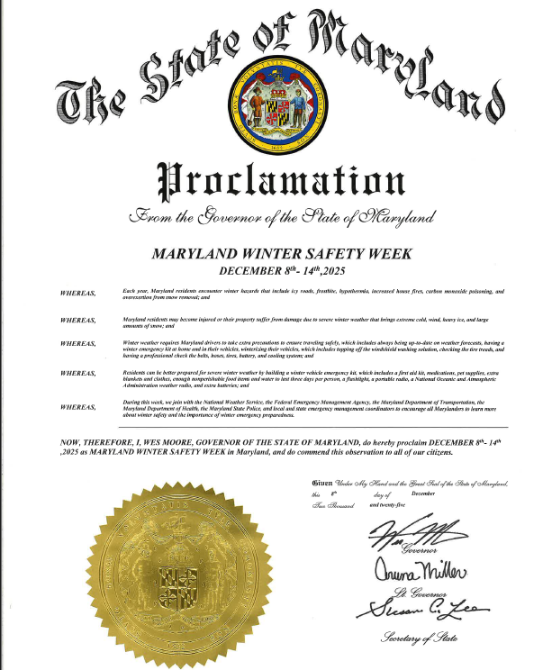
Eighth Annual Maryland Winter Safety Week Begins
December 8th, 2025MDEM, FEMA, NWS, State Agencies Partner to Increase Public’s Awareness of Winter Hazards
| HANOVER, MD (December 8, 2025) — Governor Wes Moore has proclaimed December 8 through 14, 2025 as Maryland Winter Safety Week, marking the eighth year of a statewide initiative to help Marylanders prepare for, respond to, and stay safe during winter weather. The Maryland Department of Emergency Management (MDEM) is once again partnering with the National Weather Service (NWS), The Federal Emergency Management Agency (FEMA), the Maryland Department of Transportation (MDOT), the Maryland Department of State Police (MDSP), and other State and local agencies to increase public awareness of winter hazards and promote practical preparedness steps.MDEM Secretary Russ Strickland underscored the need for advance preparation. “Each winter brings hazards that can result in injuries, loss of life, and costly damage here in Maryland,” Strickland said. “That’s why during Maryland Winter Safety Week MDEM and our partners are stressing the importance of being informed about winter hazards and what you can do to stay safe. Winter preparedness is part of what it means to be a Marylander and taking winter safety precautions seriously helps protect us all.”
Building a culture of preparedness in Maryland means weaving readiness into daily life. It’s checking in on neighbors, staying up to date on alerts, and making sure we know what to do when severe weather rolls in. Whether we find ourselves at home, work, or school, when Marylanders make preparedness part of their routine, they help each other stay safe, bounce back quicker, and stand together when things get tough. “MDEM is committed to help shape a more resilient Maryland where communities thrive,” Strickland added. “This winter, the best way to stay safe is simple: have multiple ways to get alerts, stay informed, and stay ready.” |
|
|
Weeklong Awareness Campaign
Throughout Maryland Winter Safety Week, MDEM and its partners will share safety information, preparedness tips, and interactive content across MDEM’s social media channels. This year’s campaign highlights:
- Cold-related health risks: Long exposure to extreme cold can weaken the immune system and worsen chronic conditions like asthma, arthritis, and diabetes. Vulnerable populations, including older adults and people with access and functional needs, are at especially high risk.
- Indoor heating and carbon monoxide safety: Winter brings an increase in carbon monoxide poisonings due to improper use of generators, gas stoves, or poorly maintained heating systems. If a space is unsafe for running a gas-powered tool, it is unsafe for a generator.
- Home fire safety: Residents are encouraged to use space heaters, cooking appliances, and holiday decorations safely, and to test smoke and carbon monoxide alarms regularly. Battery-operated flameless candles are a safer alternative to open flames.
- Winter travel safety: Snow, ice, and freezing rain can make driving extremely hazardous. MDEM reminds drivers to winterize vehicles and carry an emergency kit in their vehicle.
Practical Preparedness Steps
Taking small, simple steps that can make a big difference:
- Build a winter emergency kit for your vehicle. Include first aid supplies, medications, extra warm clothing, blankets, water, a flashlight, a portable radio, batteries, sand or cat litter for traction, and non-perishable snacks.
- Have ice melt, snow shovels, and sand readily available so you can safely clear walkways and prevent falls after freezing rain or snow.
- Prepare your home for severe cold by keeping a three-day supply of water, shelf-stable food, and essential medications in case travel becomes unsafe.
- Have safe ways to stay warm during severe cold. Keep extra blankets available, dress in layers, and identify a nearby warming center or a friend or family member you can stay with if you lose power.
- Stay connected and informed. Residents should have multiple ways to receive emergency alerts. Sign up for your local county and municipal emergency notification systems for your home and workplace locations.
- Use 211-Maryland. The statewide resource database offers more than 7,500 health and human service resources. Marylanders can call 211 anytime, in more than 150 languages, for assistance.
Additional information about winter preparedness can be found on our website (www.mdem.maryland.gov), X (Twitter) (@MDMEMA), Facebook (facebook.com/MDMEMA), Linkedin (linkedin.com/company/maryland-department-of-emergency-management), Threads (threads.net/@mdmema), YouTube site and Bluesky (@mdmema.bsky.social).
###
CONTACT:
Jim Abels, [email protected], 667-446-0346
Emily Ritter, [email protected], 667-446-0345
Wendy Walch, [email protected], 410-702-3480
24/7 line: 877-636-2872
MDEM Reminds Marylanders to “Know Before You Go” and “If You See Something, Say Something” as Holiday Travel Ramps Up Across Maryland
November 17th, 2025HANOVER, MD (November 17, 2025) — As Marylanders prepare to visit loved ones, celebrate traditions, and travel across the state and beyond, the Maryland Department of Emergency Management (MDEM) is recognizing Maryland Travel Safety Week (November 18–24, 2025) by reminding travelers they can take simple actions that can make every trip safer for themselves and others—whether driving, flying, or using other modes of transportation.
“The holidays are about connection—seeing family, sharing gratitude, and caring for one another,” said MDEM Secretary Russ Strickland. “That spirit of care should also guide how we travel. When we plan ahead and stay mindful, we help everyone get where they’re going safely. We wish all Marylanders a joyous and peaceful holiday season.”
Know Before You Go — Before you head out the door, stay informed and prepared so you know the travel conditions while en route to your destination. Check on road and traffic conditions along your route; check for last-minute delays or cancellations before heading to the airport or train station; and always check local weather forecasts to make sure you pack appropriate clothing and prepare for potential travel delays.
If You See Something, Say Something — If you see a suspicious activity, device, or package, or overhear a suspicious conversation, report it immediately to a facility manager, carrier employee, or law enforcement. If you see accidents or hazards along the roadway or hiking/biking trails, make sure to alert local law enforcement, highway officials, or park employees so they can respond.
About Maryland Travel Safety Week
Maryland Holiday Travel Safety Week is an annual public awareness effort led by MDEM and supported by the Maryland State Police, Maryland Department of Transportation, and local emergency management partners. The campaign encourages residents and visitors alike to prepare before traveling, remain alert, and prioritize safety so that every Marylander can celebrate the holidays safely. You can read through a variety of travel and safety tips here.
For more information, residents can also go to MDEM’s website at mdem.maryland.gov, and follow MDEM’s social media feeds X (Twitter) (@MDMEMA), Facebook (facebook.com/MDMEMA), LinkedIn (linkedin.com/company/maryland-department-of-emergency-management), Threads (threads.net/@mdmema), and Bluesky (@mdmema.bsky.social).
###
Maryland 9-1-1 Board Recognizes Excellence in Service Delivery
October 16th, 2025Event Recognized 21 Maryland 9-1-1 Specialists in the State Delivering Exceptional Service
OCEAN CITY, Md. (Oct. 16, 2025) — The Maryland 9-1-1 Board hosted its annual day of celebration yesterday evening, at the Grand Hotel Ballroom in Ocean City. Senator Cheryl Kagan delivered the keynote address following remarks by Secretary Russ Strickland of the Maryland Department of Emergency Management. Twenty public safety telecommunicators were awarded the Telecommunicator of the Year award and Kelsie Spealman of Cecil County was awarded the Marilyn Farndon Excellence in Training Award, presented by Maryland 9-1-1 Board Chair Scott Haas and Vice Chair Tammy Price.
“We are incredibly proud of the professionals who work tirelessly to protect Marylanders and support our communities during times of crisis,” said Secretary Strickland. He continued, “These are extremely important and rewarding careers and we are excited to see this field continue to grow. We are deeply grateful for the selfless role they play and enthusiastically congratulate them on their recognition.”
The annual ceremony honors Maryland’s 9-1-1 telecommunicators and celebrates excellence in 9-1-1 service delivery and training, essential components for effective emergency response. The celebration also recognizes the demanding and life-saving work that is performed by 9-1-1 specialists on a daily basis. “Our 9-1-1 Specialists and our entire emergency system might be the most invisible government employees, and among our most essential,” said Maryland State Senator Cheryl C. Kagan. “We must ensure that they are acknowledged, supported, and provided with the very best technology and training. I am proud to celebrate these courageous women and men through the Day of Celebration.”
Maryland 9-1-1 telecommunicators are the first voices that callers hear during a crisis, and well-trained telecommunicators provide crucial, life-saving instructions and coordinate faster emergency responses. This ceremony recognizes the importance of high-quality training for these professionals to perform at the highest level.
The Telecommunicator of the Year Award recognizes individuals who exemplify superior service delivery and training. This year’s recipients were:
- Sarah Braithwaite, Allegany County
- Kerrie Cooper, Anne Arundel County
- Jolanda Ellison, Anne Arundel County
- Anna Richmond, Baltimore County
- Kaylee Oldewurtel, Baltimore County
- Sarah Hugel, Calvert County
- Monique Mills, Carroll County
- Kelsie Spealman, Cecil County
- Zachary Timchula, Cecil County
- John Hackley, Charles County
- Trisha Rogerson, Charles County
- Andrea Bellevou, Charles County
- Vincent Houchin, Charles County
- Sharde Curley, Charles County
- Brittany Busche, Frederick County
- Valerie Cromer, Howard County
- Riyan Anjum, Montgomery County
- Lt. Michelle Miller, Queen Anne’s County
- Edward Dillon, Queen Anne’s County
- Cory Holm, Queen Anne’s County
- Dale Whitby, Queen Anne’s County
- Amanda Frock. Somerset County
- Christy Coffey, St. Mary’s County
- Hannah Ward, Talbot County
Kelsie Spealman, from Cecil County, received The Marilyn Farndon Excellence in Training. This award honors Marilyn Farndon’s legacy as the founding Executive Director who created Maryland’s first certified 9-1-1 training program. It recognizes instructors who advance standardized, high-quality training across the state for 9-1-1 professionals.
Maryland 9-1-1 centers are actively hiring telecommunicators, statewide. Additionally, experienced professionals can become instructors, shaping the next generation of telecommunicators. Learn more about the rewarding careers and growth opportunities at 911.maryland.gov/pages/careers.
-

- Secretary of Maryland Department of Emergency Management, Russ Strickland, provided an address to the crowd at the Day of Celebration and congratulated the recognized individuals for their outstanding service. Credit: MDEM/Jim Abels
-

- Kelsie Spealman of Cecil County was awarded the Marilyn Farndon Excellence in Training Award, which was accepted on her behalf by her supervisor (pictured here). Left to Right: William Frazier, 911 Board Member; Ashley Burgan, Vice President MENA; Tenea Reddick, 911 Board Member; Cynthia Mims, Cecil County; Scott Haas, 911 Board Chair; Russ Strickland, Secretary of MDEM; Christy Collins, 911 Board Executive Director. Credit: MDEM/Jim Abels
-

- Maryland State Senator Cheryl C. Kagan delivered the keynote address at the 9-1-1 Day of Celebration. Credit: MDEM/Jim Abels
-

- Twenty public safety telecommunicators were awarded the Telecommunicator of the Year award and Kelsie Spealman of Cecil County was awarded the Marilyn Farndon Excellence in Training Award. Credit: MDEM/Jim Abels
***END***