Heavy rains expected across Maryland
FOR IMMEDIATE RELEASE
FLASH FLOOD WATCHES ISSUED
ACROSS MUCH OF MARYLAND
Follow local forecasts, use caution while traveling
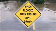
REISTERSTOWN, MD (December 20, 2018) – More heavy rain is expected over much of Maryland during the next two days as the wettest year on record continues. The National Weather Service has issued a Flash Flood Watch for all of the state except extreme Western Maryland and parts of the lower Eastern Shore. “The rain has been relentless this year and late December appears to be no exception,” said Maryland Emergency Management Agency Executive Director Russ Strickland. “Even as we prepare for the upcoming holidays, take some time to follow local weather forecasts and remember to use common sense when travelling.” Because of heavy rains last week, many streams and rivers are running high and the ground is close to saturated, so flooding is possible. The National Weather Service is predicting one to two inches of rain across most of the state, with isolated pockets of three inches or more. As of now, the flood watches are in effect until late Friday night or early Saturday morning. Additionally, the National Weather Service predicts the rain could change to snow later Friday or early Saturday in extreme Western Maryland, with accumulating snow possible. If you plan to travel through those areas, please check local forecasts closely and delay travel if road conditions deteriorate. Remember to never drive through standing water and never drive around barriers set up to block water-covered roads. Turn Around, Don’t Drown. For more flood preparedness information, please visit www.mema.maryland.gov or www.ready.gov. For current weather forecast information, visit www.Weather.gov. |