
New Report Assesses Maryland’s Coastal Resilience
 The Maryland Department of Natural Resources and The Nature Conservancy of Maryland/DC announced today the completion of a Coastal Resiliency Assessment on existing natural features that protect coastal residential communities in the state. The study identified areas that reduce the risk of coastal hazards, and determined priority areas for coastal conservation and restoration activities.
“Our coastal areas host very dynamic and ever-changing landscapes that require innovative tools, technologies and services to address weather-related challenges, such as sea-level rise,” Chesapeake and Coastal Service Director Matthew Fleming said. “The new assessment was developed by us for use by practitioners at the state and local level. It identifies areas most at risk and provides essential data on how best to enhance and improve resiliency.”
Some of the study’s key findings include:
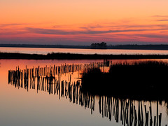
- Coastal habitats can reduce flooding and erosion impacts, with forests and wetlands playing the greatest roles. These areas significantly protect 22 percent of Maryland’s shoreline.
- Marshes play a particularly important role in risk-reduction along the Tangier Sound in Somerset County, and the Assawoman Bay and Isle of Wight Bay shorelines in Worcester County.
- The majority of high risk exposure occurs along the Lower Eastern Shore (Dorchester, Somerset, and Worcester counties).
- Shoreline hardening, transportation infrastructure, and development prevents habitat from playing a role in protection, most notably on the Western Shore. Hybrid approaches, such as living shorelines that incorporate structural components, may be more appropriate in these areas.
The department is integrating the results of the Coastal Resiliency Assessment into existing discussions, programs and strategies, and will incorporate the data into land acquisition, easement and restoration decision-making. State and local planners can apply the assessment using Maryland’s Coastal Atlas – a platform of ocean, estuary and shoreline spatial data – to identify areas of attention and focus.
The statewide assessment was conducted in partnership with The Nature Conservancy in Maryland/DC, in collaboration with the Natural Capital Project, U.S. Army Corps of Engineers, and additional federal, state and local partners.
“With over 7,000 miles of shoreline, Maryland is very susceptible to the impacts of sea level rise, coastal storms, and flooding,” Executive Director of The Nature Conservancy in Maryland/DC Dr. Elizabeth Gray said. “In light of these challenges, we will use the new assessment to guide our conservation and restoration actions for the greatest benefit to nature and people.”
To assist state and local partners on the use of the assessment, the department will be hosting two training sessions on June 15 at Anne Arundel Community College. For more information, please contact Nicole Carlozo at nicole.carlozo@maryland.gov.
 1-888-373-7888
 233733